| Click on the picture to see a larger view. Use the back button on your browser to return to this page |
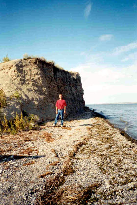 Mueller
cemetery is behind me. Mueller
cemetery is behind me. |
A Russian driver and myself departed Saratov on the morning of August 31, 2000. Equipped with maps (old and new), and a compass, and fortunate to have had many days of dry weather, we headed south along the P228. After 125 km, we turned east, towards the village of Verkh-Gryaznukha, then proceeded to Vodnobuyerachnoye (formerly Stephan), where we sought directions from local residents. With their guidance, we reached the Volga bank, where we expected to find the site of the old village of Müller (also known as Mueller, Miller and Krestovok Buyerak), birthplace of my grandfather Alexander Ebel.
After some initial wandering, we succeeded in locating only a grinding stone. Convinced that we had travelled too far north, I set off on foot to the south, parallel to the Volga bank, expecting to find Müller just over the next hill. Many hills later, the Russian village of Shcherbakovka came into view. Realizing my mistake, I headed back towards my starting point. When I had almost completely retraced my steps, from the top of a hill, I caught sight of some old walls, a few hundred metres from the Volga bank. Müller had been found.
After exploring the ruins, I caught up with my driver who had, with the help of some locals relaxing on the river bank, located the Müller cemetery.
While traversing the area on foot, I made a photographic record of the sights, including the Müller ruins, the cemetery and the Volga bank.
After some further exploration, we returned to Saratov, via the Danilovka road to the P228.
Topography
The area around Müller is hilly and traversed by many gullies leading to the Volga. There are stands of trees in the area. The gullies themselves are generally filled with dense vegetation, making them difficult to cross on foot.
There is an abundance of sandstone in the area. From a distance, the sandstone outcroppings can sometimes be mistaken for walls or other human constructions.
Rural roads are in poor condition and difficult to navigate even when completely dry, due to large bumps, deep ruts and steep slopes.
Hydroelectric dams downstream have raised the river's water level, which has had the effect of widening the Volga banks. Consequent erosion has led to the formation of steep cliffs along most of the bank. However, there are places where the ground slopes gradually to the river, and it is possible to drive a car to the edge of the water. The Müller cemetery is near such a location, although the cemetery itself is on higher ground.
Old maps of the area show that Müller once faced the northern tip of an island in the middle of the Volga. That island is now completely submerged.
Description of the Müller Site
Located at the edge of the river, the cemetery is overgrown with grass and weeds and gravesites are not immediately evident. Individual burial sites appear to have imploded, with headstones falling into the resulting depression. We did not attempt a thorough survey of the site, and writings or markings were not evident on the few headstones we looked at.
Where the cemetery meets the river, there is a steep cliff. According to local residents, bones from the cemetery may sometimes be seen eroding out of the cliff and falling into the river below.
To the south of the cemetery, the ground slopes gently to the water. Local residents use this area for fishing or relaxing.
Behind the cemetery, further from the water, is evidence of old buildings. All of these appear to have been constructed from layers of sandstone bound together with a mixture of mud and grass. Such materials seem vulnerable to erosion; mostly there were numerous overgrown piles of mud and rock. However, I found four walls standing from a single building (no roof) as well as a few other wall remnants from other structures.
A few old grinding stones were also found in the area.
There were also some wooden electrical posts which remain vertical, but appear to have sunk into the ground. Near them was the roof of an old truck. It was not clear to me whether these items dated back to the final days of Müller's habitation, or whether they were more recent artifacts. Electrification would have obviously been undertaken only for an inhabited area. However, from visual inspection, I assumed the posts and the truck roof were probably just a few decades old.
There were also signs of recent campfires; whether these were started by local residents or transients is unknown.
The Russian name for Müller 'Krestovok Buyerak' means crossed gully. The wall remnants I discovered were located between two intersecting gullies thick with vegetation, making movement between the town site and the river difficult.
Finding the Müller site took us considerable time. The drive to the site, including stops for directions, required three hours. This was followed by another hour and a half, during which I hiked south towards Shcherbakovka and back, before finally catching sight of the Müller ruins. With the day passing quickly, we spent only about ninety minutes actually exploring the ruins and the cemetery. Considering the village had a population of 2488 in 1912, I am certain there remains more to be found by a systematic search of the area.
Location of Müller
Müller is located on the west bank of the Volga, between the cities of Saratov
and Kamishyn. In a straight line, Müller is about 100 km from Saratov. However,
by car the trip is longer and takes almost three hours, due primarily to the
poor quality of rural roads. The Müller site seems to lie on the border between
two administrative regions, Saratovskaya Oblast to the north, and Volgogradskaya
Oblast to the south.
From Saratov, there is a main highway south, the P228. At the border between the two oblasts, there is a sign on the east side of the road, welcoming vehicles travelling north to Saratovskaya Oblast. Here, there is a turnoff for the village of Danilovka. Following this road will lead through Danilovka to Vodnobuyerachnoye, the village formerly known as Stephan. This is the nearest inhabited village to Müller, and here it is necessary to ask local residents the precise roads to take to the Müller site.
The local residents were extremely helpful. However, they had some difficulties in understanding our objective. Fortunately, we were equipped with some old maps from the 1930s, which we used to refresh people's memories. The locals also insisted there was nothing at the site, until we explained that finding a few ruins was our goal.
Finding the Exact Site Directions from the locals guided us right to the edge of the Müller site. Despite this, finding the village and cemetery required considerable searching, due to the cover of hills, gullies and vegetation. Only from the top of a nearby hill was I finally able to see wall remnants.
About five kilometres south of the Müller site, along the Volga bank, is the Russian village of Shcherbakovka. If you reach this site by foot (as I nearly did) or by car, you'll know you're in the wrong place, although there are people here who can direct you to Müller.
On the Volga bank opposite Müller is the village of Belokamenka. However, there are a variety of village structures spread out along the opposite bank, making them of little use for finding your position.
What You Will Need To Find Müller
· New maps (to locate roads, villages and turnoffs) of Saratovskaya or Volgogradskaya
Oblast. My maps were purchased in Saratov, at Saratovkniga, on the corner of
Prospect Kirova and Ulitsa Volskaya.
· Old maps, showing the location of Müller in relation to other villages and topography. Map M-38-56 of Saratovskii Krai of the German Autonomous Soviet Socialist Republic from 1934 was ideal for the purpose. William M. Wiest of Portland, OR sent me a copy of the relevant section of this map set which consists of 36 pages in all. The entire set is available from the American Historical Society of Germans from Russia, which we understand obtained this old historical map set from Professor Pleve of Saratov.
· A compass is helpful in getting from the P228 to the Volga along some very winding roads.
· A car and Russian speaking driver. My driver, Volodya, was exceptionally patient and helpful. Due to the Russian economic climate at the time of writing, there are many Russians willing to be hired as a driver for such a day trip. With a few days notice, Russian friends or contacts in Saratov should be able to find a reliable driver by word of mouth. Volodya was a colleague of my Saratov hosts.
· An interpreter. My Russian language skills were sufficient to make this trip without an interpreter, although I had to rely on Volodya to ask for precise directions from local inhabitants. Finding an interpreter may require a bit more effort, but can probably also be found in the same manner as a driver.
· Dry weather.
· Exact directions from the residents of Vodnobuyerachnoye.